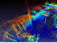
Zebedee is a small hand-held device that consists of a lightweight LiDAR scanner with 30m (100ft) maximum range and a industrial-grade MEMS inertial measurement unit (IMU) mounted on a simple spring mechanism. As an operator holding the device moves through the environment, the scanner loosely oscillates about the spring, thereby producing a rotation that converts the LiDAR's inherent 2D scanning plane into a local 3D field of view. With the use of proprietary software, the range measurements can be projected into a common coordinate frame to generate an accurate 3D point cloud in real-time. To achieve this result, the software must estimate the six degree of freedom (6DoF) trajectory of the scanner on top of the spring solely from the available range and inertial data.
The challenge of concurrently building a map and estimating motion in an unknown environment without an external reference system is a well-known problem in the robotics community called Simultaneous Localization and Mapping (SLAM). The general operating principle behind Zebedee can be understood by considering the simplified example of a range sensor measuring the surface of a flat wall. As the sensor moves towards the wall, the range measurements associated with that surface decrease in magnitude. The motion towards the wall can therefore be inferred by the observed change in distance to the wall. By integrating thousands of similar relative observations of many surfaces over time, and making reasonable assumptions about the platform’s dynamics, the 6DoF trajectory of the sensor can be estimated with considerable accuracy. The oscillatory behavior of Zebedee ensures that surfaces are re-observed at a sufficient frequency to estimate the sensor motion while the operator moves at a walking pace.
Zebedee’s ability to self-localize enables its use in indoor, underground, and otherwise covered environments such as dense forest. In contrast, traditional mobile mapping systems utilize independent positioning systems, which in most cases consist of a combination of GPS and high-quality inertial sensors or tripod mounted tracking systems. Systems relying on GPS will not function indoors over the long-term---even the available high-end inertial systems will drift significantly over time without an external reference, and tripod based trackers are limited by range and line-of-sight.
As a handheld sensor, Zebedee can go almost anywhere a human can. Its simple mechanical design results in a lightweight package of under 400g. In addition to the handheld hardware, a data acquisition computer and small battery (sufficient for a full day of operation) can be stored in a wearable unit, such as a backpack. Unlike wheeled mobile platforms, Zebedee can be operated on stairways and on rough terrain, allowing for seamless mapping between levels, interiors and exteriors, and multiple buildings. Our proprietary SLAM algorithm does not require any particular artificial structure such as flat walls, floors, or ceilings; therefore, both natural and built environments can be mapped.
Additional Material.
Zebedee: Design of a Spring-Mounted 3D Range Sensor with Application to Mobile Mapping, IEEE Transactions on Robotics, 2012, to appear. http://dl.dropbox.com/u/7114463/final_versions/bosse_tro2012.pdf
THREE DIMENSIONAL SCANNING BEAM SYSTEM AND METHOD. WO/2012/012819
Video
-
Awards
-
 2012 Top 100 Entries
Like this entry?
-
About the Entrant
- Name:Elliot Duff
- Type of entry:teamTeam members:Elliot Duff
Mike Bosse
Robert Zlot
Paul Flick
Peter Kambouris - Software used for this entry:Matlab
- Patent status:pending


